Monday, September 17, 2012

It's About Time

I finally hiked a 14er this hiking season. It is has been hard to try and fit one in this season. I wasn’t as in shape as I would like to be in order to attempt one. It was pretty much now or never though. Anyway, I climbed Huron Peak on Sunday. Summit Post has the elevation at 14,012 feet. I have seen other sites that have the elevation at 14,009 and 14,010 feet. My map has it as 14,003 feet. That is an old survey though. I started my hike at Winfield which is a ghost town. The starting elevation is around 10,260 feet. The first two miles of my hike was on a 4-wheel drive road. I don’t have a 4WD vehicle, so I had to hike it. The first two miles were easy. My elevation was only around 10,600 feet at the end of the 4WD road. The trail was a steady up from here. The trail was great and not too steep considering that from the end of the 4WD road to the top was only two miles. The only place that felt overly steep was the last quarter mile. That was more me not spending enough time at elevation this year. I have certainly hiked tougher 14ers. Here are my pictures.
Early morning view, near tree line.
Huron Peak
A touch of snow near the false summit
Ice Mountain and The Three Apostles
The Top
LaPlata Peak (left) and Mt. Elbert (Right)
Me on Top
Looking at The Three Apostles
Lake Ann, Continental Divide, & Taylor Park Reservoir
Looking west on the way down
Silver Basin (left) and Virgina Peak & Winfield Peak (Right)
View from the 4WD Road
Clear Creek
Fall Color near Winfield

Saturday, September 08, 2012

The Bitter End (Part III)

After a busy Friday, I spent Saturday in Portland. I took light rail across town to Washington Park. I went for a walk in that park and ended up in Forest Park. Between the two parks there are over 80 miles of trails. I walk to Pittock Mansion in Forest Park. The mansion overlooks Portland and has lots of beautiful flowers.
Pittock Mansion
Flowers at Pittock Mansion.  Mt. Hood is barely visible thru the haze.
I walked back to downtown from Pittock Mansion. It was interesting walk by houses that are squeezed into small sloped lots on the hillside. I had lunch downtown and then went to Powell’s Books which is also known as Powell’s City of Books. It is a bookstore that takes up an entire city block. There is a claim that it is largest independent bookstore of new and used books in the world. It certainly is the biggest bookstore that I’ve been to. They had an incredible selection of books.

On Sunday, I went back into the Columbia River Gorge. I drove to Crown Point on the Oregon side of the Columbia and ate my breakfast while I enjoyed the view of the Gorge.
Looking west from Crown Point
After breakfast, I drove down the scenic highway looking for something to do. I thought about stopping at Latourell Falls, but the trailhead was closed due to construction. I drove to Multnomah Falls. It is the Columbia River Gorge’s most famous and popular waterfall. I was there early enough that it wasn’t too crowded. Multnomah Falls has two falls. The upper one has 542 foot drop and the lower one has a 69 foot drop. With an elevation change of 9 feet between the falls, the total height of the falls is 620 feet. The parking lot is pretty much at the base of the falls. So I basically got out and took some pictures and moved on before it got too crowded.
Multnomah Falls
Multnomah Falls
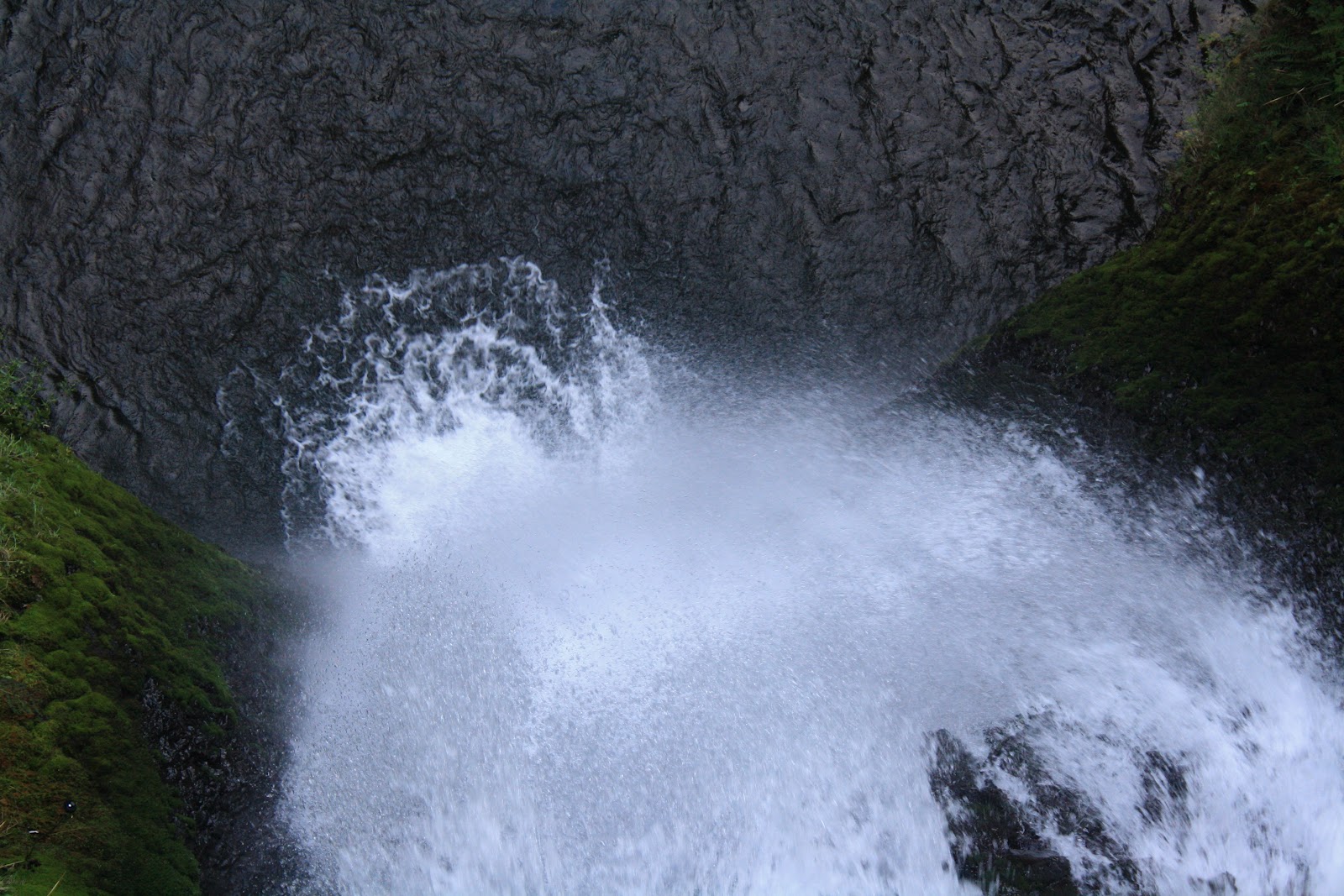
Looking down from the bridge at lower Multnomah Falls
My final stop of the trip was a hike to Wahkeena Falls and Fairy Falls. Wahkeena Falls was a short easy hike. Fairy Falls required a little bit of elevation gain, but it wasn’t too bad. After the hike, it was time to get cleaned up and go home.
Wahkeena Falls
Fairy Falls
Wahkeena Creek
And now for the Bitter End: I generally have some type of odd ball reference in my blog titles. Usually they are song titles. This blog title is no different. “The Bitter End” is a name of a song by a band called Blind Pilot who are from Portland. The Bitter End is also the name of one the bars where the Timbers Army hangs out. The original reason for being in Portland was a soccer game between the Colorado Rapids and the Portland Timbers. The Rapids are having an awful season so that reason has become secondary. The game was Friday night, but I’m putting its story at the end to fit the title. The Timbers’ fans were still friendly to us. I was told that they were going to hate us for two hours and then it is back to being friends again. The atmosphere in the stadium was great once again. The game was not so good. The Rapids lost 1-0. The Rapids dropped to last place in the Western Conference. Hence, the bitter end…
Timbers Army after the goal
P.S. – The Rapids climbed out of last place by beating Portland on the return trip on Wednesday. I was sick and missed my first home game of the season. So it is still a bitter end.

Tuesday, September 04, 2012

The Bitter End (Part II)

For my third hike on Friday, I did a loop hike that was full of waterfalls. The first falls on the hike was Horsetail Falls. Horsetail Falls is quite popular. It is right at the trailhead. I had to walk across the street to see this waterfall.
Horsetail Falls
The second falls on the hike was Ponytail Falls. The trail goes behind Ponytail Falls.
Ponytail Falls
Ponytail Falls
Behind Ponytail Falls
Columbia River, Hamilton Mtn., & Beacon Rock
Oneonta Falls was third waterfall on my hike.
Oneonta Falls
The final set of falls on this hike was Triple Falls. This waterfall features three waterfalls from the same creek that falls into one splash pool.
Triple Falls
Log at the top of Triple Falls
This next picture was an attempt to capture all the different shades of green I was seeing. Seeing all the green of this part of Oregon was a fun change of pace from the everyday brown that I have been seeing a lot in Colorado this year.
Moss filled trees
To Be Concluded...

Monday, September 03, 2012

The Bitter End (Part I)

I was in Portland, Oregon this past weekend for some soccer and hiking. I have a lot of pictures so I’ll do multiple posts. I did three different hikes in the Columbia River Gorge on Friday. I’ll cover the first two hikes with this post. The first stop was Beacon Rock. Beacon Rock is on the Washington side of the Columbia River. It is 848 feet tall and 142 river miles from the ocean. The rock is the core of an old volcano. Before the Columbia River was tamed with dams, it was a landmark for the first set of rapids that were located a few miles upstream from Beacon Rock. Lewis and Clark named it Beaten Rock on their journey down the Columbia in 1805. They renamed it Beacon Rock on the return trip in 1806. Lewis and Clark also noticed that Beacon Rock was the eastern extent of the tidal influence on the Columbia River. The tidal influence is pretty impressive considering how far Beacon Rock is from the ocean. A trail up Beacon Rock was completed in 1918. The trail is 0.9 miles long. Here are some photos of the Beacon Rock hike.
Trail up Beacon Rock
Looking East from the top of Beacon Rock
Hamilton Mountain from Beacon Rock
Looking west from Beacon Rock
Columbia River and Beacon Rock from Bonneville Dam
After the Beacon Rock hike, I drove across the Bridge of the Gods to the Oregon side of the Columbia River. The next hike was to Wahclella Falls. The hike is a 2 mile round trip. Not too far into the hike there was a nice surprise in the hike. There was a waterfall that wasn’t in the trail data that I had. It was on a blind corner, and a bridge goes right in front of it. The falls is called Munra Falls.
Munra Falls
The hike to both falls was easy. The Wahclella Falls trail makes a lollipop loops. I recommend the right fork for better approach views of Wachella Falls.
Wahclella Falls
Wahclella Falls
Wahclella Falls
To Be Continued...